Mini Review | DOI: https://doi.org/10.31579/2766-2314/105
*Corresponding Author: Zakir Aliyev, Institute of Soil Science and Agrochemistry of ANAS, Baku.
Citation: Aliyev, Z.H. Aliyev, (2023), The Process of Degradation of Agricultural Land in Azerbaijan Under the Impact of Water and Wind Erosion and Background of Its Development, J, Biotechnology and Bioprocessing, 4(4); DOI:10.31579/2766-2314/105
Copyright: © 2023, Zakir Aliyev. This is an open access article distributed under the Creative Commons Attribution License, which permits unrestricted use, distribution, and reproduction in any medium, provided the original work is properly cited.
Received: 19 June 2023 | Accepted: 29 June 2023 | Published: 05 July 2023
Keywords: water erosion; wind erosion; crops; soil processing; antierosion actions; agrotechnology; Lugo melioration; agrolesmelioration; hydraulic engineering
This article provides information about the causes of water and wind erosion, areape, damage caused to agricultural lands, activities on prevention and rehabilitation of land disturbed by erosion.

Soil degradation is currently one of the most important socio-economic problems that poses a threat to environmental, economic and, in general, national security in Azerbaijan.
Water erosion and deflation is one of the main types of degradation, which is characterized by the destruction and depletion of the soil cover. At the same time, its physical and chemical properties change, the water regime worsens.
It is also one of the most powerful modern relief-forming processes, moving huge masses of matter within the boundaries of economically developed lands, a significant source of environmental pollution with chemical components of the soil and pollutants introduced into it, one of the root causes of pollution of small rivers and degradation of agricultural landscapes.
In general, the total amount of damage from soil erosion and deflation in Azerbaijan, according to the most conservative estimates, is approximately 10-11 billion manats. per year [6].
The causes of erosion and deflation are practically the same, so they cannot be considered in isolation from each other. The main ones are:
-constant reduction of the area with natural vegetation with high soil-protective properties;
- high degree of economic development of landscapes, involvement in the intensive use of disturbed and degraded lands;
- imperfect forms of organization of territories of agricultural landscapes;
-violation of agricultural technology of cultivation of agricultural crops;
-ignoring the development of a complex of scientifically based soil protection measures;
- unfavorable combination of natural and climatic conditions of farming.
It should be noted that the limited land resources in the lowlands, the specific indicator of the provision of irrigated land per capita (0.18 ha), which is developing in the future, the difficult demographic situation, as well as the agrarian policy of the republic, require finding additional opportunities for expanding irrigated land at the expense of the foothill zone.
Azerbaijan. In this regard, it is necessary to further improve the principles of studying and using the totality of soil, agro-climatic, hydrological and other resources of the mountain belt of the Republic in agricultural production, including the creation of a scientific concept that makes it possible to analyze in detail the soil-climatic environment of these lands, to establish a territory suitable for irrigation, to develop complex forecasting for the purpose of their reclamation development.
Object of study
Most (65%) of the irrigated areas, and there are more than 1.4 million hectares in Azerbaijan, are located on sloping lands, characterized by varying thickness of the soil profile and degree of erosion. The mountain-foothill zone where these territories are located is characterized by difficult relief conditions and occupies 60% of the country's territory.
Large physical and geographical areas - the Greater and Lesser Caucasus, the Kura-Araks lowland and the Talysh Mountains zone are very different in geological structure, climate, soil cover, slope steepness, which varies from 0-45˚ and more. The depth of local erosion bases ranges from 28-1000 m and more.
At present, it is very important not only to expand the agricultural land fund of the Republic at the expense of mountainous regions, but at the same time to establish a territory suitable for irrigation.
The discussion of the results
The mountainous zone of Azerbaijan has favorable natural-climatic and economic conditions for agriculture. There is enough heat for cultivated crops, a sufficient amount of moisture falls.
Most of the zone is heavily saline and has good transport links. Large areas of agricultural land, with the rational use of local water resources, can make it possible to produce here such a quantity of agricultural products that would satisfy the growing needs of the population of the Republic.
However, in order to realize the enormous potential of agriculture in mountainous and foothill areas, it is necessary to carry out their typification and zoning, the identification of lands suitable for agricultural use with a further assessment of their reclamation disorder (high slope, fine contour, moisture deficiency, fertility, etc.). With purpose set. We carried out a morphometric analysis of river basins located in economic regions in the mountainous part of the republic (Table)
It should be noted that the territory of Azerbaijan, located in different belts, is indented by numerous rivers, the basins of which have different shapes and sizes. The shape, size, exposure of slopes and other elements of river basins, on the one hand, are important indicators characterizing the horizontal and vertical division of the country's territory, and on the other hand, it becomes of great importance in the further development of irrigated lands and the study of their specific irrigation features.
Each of these elements influence irrigation conditions in their own way, playing a certain role in the complex process of interaction between irrigation and the geographic environment.
It should be noted that in the conditions of Azerbaijan, the formation of the main component of water resources - river runoff is very difficult. The water regime of rivers is mainly formed in mountainous and high-mountain areas, and in low-mountain, especially in low-lying areas, rivers flow in transit and their regime formed in the mountains does not undergo significant changes in these areas.
In early, seepage and parsing of water for irrigation. It is characteristic to note that the average annual amount of precipitation falling on the territory of the republic is 427 mm. In contrast to this, the total evaporation, according to water-balance studies, is 308 mm, and the local runoff is + 19 mm, i.e., evaporation is 2.6 times higher than the runoff.
The territory of the republic with an area of 86.6 thousand km2, consisting of 60% mountainous and 40% flat fields, is divided into 72 districts with a population of 9.2 million people.
At the same time, it should be taken into account that our analysis of agro-climatic indicators from these 72 regions of the republic, 14 of which are located in the zone of the Talysh and Lesser Caucasus mountains, shows that the average annual temperature in these regions is 7-140 C, providing the possibility of cultivating various agricultural crops (in including potatoes, wheat, tobacco, etc.).
However, the decrease in annual precipitation (300-600 mm) during the growing season does not make it possible to obtain large yields of these crops.
Therefore, by carrying out appropriate reclamation measures, it is possible to achieve an increase in a large crop yield by expanding the sown fields and expanding irrigated lands.
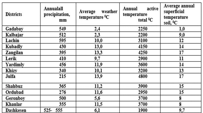
Table 1: Agro-climatic indicators of the mountainous regions of the Azerbaijan Republic
It should be noted that all types of erosion occur in Azerbaijan (including water, mudflow, wind, surface, linear, etc.). The susceptibility to soil erosion in the mountainous regions of Azerbaijan is shown in Table 2.

Table 2: Susceptibility to soil erosion in the mountainous regions of Azerbaijan
As can be seen from the table, the most common is water erosion, which develops more intensively in mountainous regions.
The soils of mountainous areas are subject to erosion to this and other degrees, which covers 51.0-92.4% of the land area. In the Shahbuz and Ordubad regions of the republic, soils were subjected to severe erosion and, respectively, account for 54.3 and 67.2%. [1.3 and others]
The above mountainous regions, thanks to the collection of mudflows in small reservoirs, more than 1300 hectares of wet or uncultivated soils carry out irrigation, which serves. IT to prevent mudflow and irrigation erosion in these areas.
In addition, by reducing soil erosion, introducing a number of measures, incl. providing the soil with sufficient amounts of mineral fertilizers in these areas, it is possible to achieve the production of 35.0 thousand tons of wheat, 12.0 thousand tons of tobacco, 10-15 thousand tons of vegetables, 95-100 thousand tons of potatoes, as well as due to the improvement of fodder base to significantly increase the production of livestock products. [1,2,4.]
As a result of all this, it will be possible to employ a significant part of the population of this region and improve the social living conditions of the population.
A study of the morphometric indicators of the characteristic river basins of the mountainous zones of the country was carried out on the basis of geomorphological maps, using materials on regional soil, climate, and hydrological studies, which were carried out by various institutions of the Republic [3].
Geomorphological maps of an analytical type, which were compiled by the staff of the Institute of the National Academy of Sciences of the Republic of Azerbaijan for certain natural and economic regions of the republic, are intended to solve irrigation and reclamation issues.
In addition to the general geomorphological characteristics of the relief and the display of surface deposits, it provides extensive additional information necessary for the development of design and selection of irrigation areas.
The definition of morphometric indicators on the map was carried out by us according to the skeletal (abbreviated) scheme. Skeletal analysis began with the identification of river thalwegs on maps.
Next, sequentially found terraces of the first, second and third order. Also, watershed areas were identified sequentially by constructing watershed lines.
Drawing up the scheme of vertical planning, we limited ourselves to the allocation of only the largest terraces of the corresponding catchment areas.
At the same time, it was taken into account that the features of irrigation systems in various morphogenetic types of relief are determined by a combination of natural factors, the main of which are the following: the prevailing slopes of the surface, the density and depth of dissection, hydrological and soil-reclamation conditions.
The assessment of the territory according to the prevailing slopes of the surface in irrigation is associated with the possibility of using one or another method of irrigation. The possibility of their application is determined by the corresponding slope values. The maximum value of slopes, at which irrigation development of the territory is possible with the use of sprinkling, as the most progressive and universal method of irrigation, is a slope of 0.05.
Hence, territories with slopes greater than this value are excluded from irrigation development. Slopes in the range of 0.02-0.05 characterize hard-to-master surface irrigation techniques.
A slope of 0.002 within platform plains delimits low and high plains; in irrigation, it defines the boundary of the possible application of irrigation methods along strips and furrows. Floodplains of large lowland rivers have slopes of less than 0.0005, from 0.002 to 0.005; floodplains of small rivers and large beams, as well as river terraces, etc.
The mountain areas suitable for irrigation are confined to the terraces of river valleys, alluvial fans and mountain slopes.
Floodplain terraces inundated by floods are usually difficult to use for irrigation due to relatively sharp fluctuations in water levels in rivers, the small width of terraces, and swamping and sedimentation common in the floodplains of a number of rivers and sedimentation during maximum flows. The most characteristic example of such patterns is observed on the river basins of the southern slope of the Greater Caucasus.
Irrigation can be developed to the greatest extent on high terraces, where there are comparatively favorable conditions for water intake and sediment control, where waterlogging and salinization are absent. The relatively thick and fine-earth cover and developed soils make it possible to use river terraces entirely for irrigated areas of high productivity.
In these areas with a relatively correct configuration of the irrigation network, it is possible, within certain limits, to apply progressive irrigation methods and irrigation techniques. The low terraces of the river valleys used for irrigation require, as a rule, embankment of the riverbeds. The water intake is extremely favorable, the relief of the floodplain terraces is characterized by small hillockiness.
According to the conditions of the relief, it seems possible to have plots of the correct configuration, which contribute to the use of an expedient method and technique of irrigation in the design of irrigation measures.
Irrigation of mountain slopes, located mainly at an altitude of more than 1200-1800 m, composed mainly of landslides and screes, is associated with great difficulties, which is observed in the Pirsagatchay valleys. Irrigated areas remote from irrigation sources and located at high altitudes usually require the supply of water over long distances through channels drawn either in slopes or in screes. In both cases, very significant filtration losses are observed.
At the points of possible withdrawal for irrigation, tributaries of the river, flow those near mountain slopes often have only periodic flow, and irrigation here is often associated with flow regulation, which is extremely difficult due to difficult topographic conditions.[5]
Piedmont zones, usually located at an altitude of 200 to 800-1000 m, are characterized by a relatively small amount of precipitation - from 200 to 600 mm (the exception is the foothills of the Talysh mountain system).
A special position in the foothill zones is occupied by river valleys, within which high and low terraces can be distinguished.
Depending on the amount of precipitation, slope exposure and other physical and geographical factors, each of these types of terrain may have slightly different operating conditions for irrigation systems.
However, the main features inherent in each of these types can be easily noticed when considering specific irrigated areas.
The most important from the point of view of irrigation in this area are alluvial fans, on which a significant part of the irrigated areas in the Shirvan, Sheki, Ganja and other natural and economic zones are currently concentrated. [7]
Depending on the nature of the supply of sources that form alluvial fans, irrigation of these may require flow regulation.
As a rule, alluvial fans of the rivers of Azerbaijan are formed by streams with sharp fluctuations in runoff.
Taking into account the annual flow regime of local rivers and water shortage during the growing season of agricultural crops, the task of regulation is to retain water during floods and floods, and use them during a critical period. The formation of water reserves is achieved in such sources mainly due to the accumulation of winter and autumn runoff.[8]
The issues of creating stable horizons in the case of water intake on the foothills are of little importance, since the river, as a rule, commands over the surface of the alluvial fan, and the withdrawal of water to one point or another is possible without backwater.
With limited slopes of the river, it is advisable to carry out water intake for low terraces using alluvial installations. Water intake for irrigation of high terraces is more difficult than for irrigation of low ones.
Regulation of water horizons by erecting water-lifting dams may be expedient only with relatively small fluctuations, flow rates, or with a large area of irrigation.
At high costs and a limited area, machine water lifting should be used, since gravity water intake is associated with the construction of a part of the main canal of considerable length.
1.According to the relief, Azerbaijan is divided into flat regions, occupying 40% and mountainous regions, 60% of its territory. Despite the diversity of environmental conditions, the issues of agriculture, land reclamation and agricultural technology in the mountainous part of the republic have not been sufficiently studied and require further research.
2. The soil cover of foothill and mountainous areas is well drained and rich in nutrients. The humus content in the upper horizon ranges from 2.5-3.8% in the chestnut soils of the foothill zone and up to 7-8% in the mountain brown and brown soils.
3. By conducting a morphogenetic analysis, taking into account the physical-geographical and economic conditions of the territory, it was possible to establish lands suitable for irrigation, evaluate them according to the prevailing slopes.
4. On the territory of the mountainous region of the republic, 1620.5 thousand hectares of area are suitable for agricultural development in irrigated agriculture.
Of these, 1,364.2 thousand ha fall to the share of low-mountain and foothill regions (200-1000 m), and 258.3 thousand ha in medium and high-mountain regions (more than 1000 m).
Dear Editorial Team, Clinical Medical Reviews and Reports. My experience with the journal was highly positive. The peer-review process was rigorous, constructive, and completed in a timely manner. The reviewers provided valuable comments that helped improve the quality and clarity of our manuscript. The editorial office was professional, responsive, and supportive throughout all stages of the publication process. Communication was clear and efficient, and any questions were addressed promptly. Overall, I found the journal to maintain high scientific standards and an excellent publication workflow. I would be pleased to consider submitting future work to this journal. Best wishes from, Elena Popa.

It was my pleasure to submit my testimonial concerning the Reviewer Board of our Scientific Journal “Brain and Neurological Disorders”. The Reviewers focused on some modifications and their contribution was helpful. The ladies of our Editorial Office were also supported my efforts. It was my honor to have such a co-operation and I am looking forward for more collaboration.
Dear Grace Pierce, Editorial Coordinator of Journal of Clinical Research and Reports, Thank you for the speedy and efficient peer review process. I appreciate the fact that your peer reviewers do not take months to respond like with some other journals. I would also like to thank the editorial office for responding quickly to my questions. It is an excellent journal. I plan to submit more manuscripts in the future. Best wishes from, Robert W. McGee

Dear Grace Pierce, Editorial Coordinator of Journal of Clinical Research and Reports, Working with you and your team on our recent publication in JCRR has been a truly wonderful and enjoyable experience. The responses were prompt, and the reviewers were patient, constructive, and highly professional. One reviewer in particular gave me the feeling that a professor was carefully reading and commenting on my coursework, which was deeply touching. The entire process was straightforward and hassle‑free, with no tedious online forms to complete. I highly recommend this journal. Best wishes from, DR Aibing Rao, Head of R&D

I Appreciate the Opportunity to Share my Experience with the Journal of Clinical Research and Reports. The peer review process was timely and constructive, and the feedback provided helped improve the quality of our manuscript. The editorial office was professional, responsive, and supportive throughout the process, ensuring smooth communication and efficient handling of the submission. Overall, it was a positive experience collaborating with your team.

Dear Mercy Grace, Editorial Coordinator of Obstetrics Gynecology and Reproductive Sciences, We would like to express our gratitude for your help at all stages of publishing and editing the article. The editors of the magazine answer all the necessary questions and help at every stage. We will definitely continue to cooperate and publish other works in the Obstetrics Gynecology and Reproductive Sciences! Best wishes from, Alla Konstantinovna Politova,